Recently I needed a forest road map for an encounter, and my creativity was running a bit low. The best I could come up with was the standard “road with trees on either side.” Online aerial maps helped me break out of the creative slump, and I thought I’d share some of my observations here.
FINDING THE RIGHT MAP
If you’d like to find an aerial map, you may wish to start close to home. Need a warehouse district for your modern game? I bet you know some areas in your town or from somewhere you’ve lived in the past. Your local supermarket, downtown, or park can provide great fodder for maps. For my forest road, I chose an area near my parents’ house with lots of trails. I know the area well and within a few minutes I had a map I could use.
Choosing a familiar area allows you to provide realistic details while you GM. After all, this is your old stomping grounds, though the players don’t need to know that. Also, it makes it much easier to ad-lib if they surprise you or go “off map.”
Of course, you aren’t limited to your own town. If you run a modern game, imagine an adventure based around Mount Rushmore or Times Square. If you run a fantasy or historical game, check out some European castles, Stonehenge, or Machu Pichu. There’s even Google Mars.
Now that you’ve found your map, let’s look at where you might go from here.
USING THE MAP AS IS (MOSTLY)
If you’ve found the right map, you may be able to just crop it and run. If you are using a virtual tabletop, you may wish to shrink the size a bit, and lower the quality of your jpeg image to about 90%. This will help keep your filesize manageable. If you need a print version, consider the free site blockposters.com. They allow you to upload and slice your image to the desired size. Then it will create a pdf for you. Print it out, glue or tape it together, and you’re ready for a tabletop game.
You may need to doctor your map a bit. Suppose you need a UFO landing site. Find a nice field, paste a spaceship onto a separate layer, and then adjust the sizes to your needs. You can easily add statues, vehicles or even a dead Celestial in the same way.
REDRAWING THE MAP
Sometimes finding a game-ready map just isn’t possible. Often the resolution may be too grainy, or there may be undesired elements on the image. That asphalt highway just may not cut it in Middle-Earth. When that happens, you can still use the aerial map for inspiration.
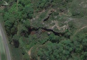
Let’s look at an example. Here’s the forest road that started this whole thing. It has a hill, an open field, short cliffs, and some rubble from past mining in the area. Overall, it is much more varied than what I originally had in mind.
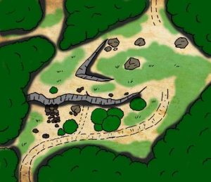
Now here’s the hand drawn map. It was sketched in pencil, and then inked with a drawing pen. It was then scanned into the computer and colored with paint.net. You’ll notice I simplified it a bit, and added the suggestion of a couple side roads to the east and northwest. Maybe they’ll go check those out at some point in the future. Redrawing the map gave me the freedom to make some adjustments.
If you feel your artistic skills are lacking, you can still use aerial maps. Print one out, and then use a lightbox or a window to trace over the parts of the image you want. Move roads, buildings, etc… as needed. Your players will appreciate the map, and you probably draw better than you think.
CONCLUDING THOUGHTS
Aerial maps have their limitations. Not every locale is available, and sometimes you’ll want a more custom site. However, they can be a great source of inspiration, and often a timesaver. If you have any experience or thoughts about these kind of maps, share them below.






I did just this once when I wanted my party to go to a castle on an island. Some googling later I found Kisimul Castle in Scotland, with a detailed map on Wikipedia, which gave me all the inspiration I needed to run a couple of encounters there.
Thanks so much!!!Kisimul Castle is now in my evernote for me to check out.
Also, take a look at Skellig Michael. It’s an abandoned monastery on an island, just ripe for an RPG session or so. They are also using it in the upcoming Star Wars 7.
our ongoing marvel game makes great use of street view in the modern London setting as well, i use it more or less every session: feel free to check out our web site too 🙂
EDIT
last comment failed to display the link to our game, and called the link spam… here is the link again
https://knights-of-albion-1.obsidianportal.com/
I’ve long been a big fan of snagging interior or exterior maps/photos from the internet. Google Earth has been a nice resource for sparking ideas on terrain layouts or even just a top view of a downtown crossroads loaded with cars and buildings.
I’ve used maps of the Smithsonian, Grand Central Station, and even the Fresno Yosemite International Airport (good old FAT). With the Smithsonian I utilized the venerable Museum of Natural History for a Spirit of the Century game. Grand Central Station was a nice starting point for a major Transit Rail Station on Corellia. And FAT had the core elements needed to create a small starport.
Just some photos of places like warehouses, malls, and city parks might provide the inspiration needed to create some scene enhancing maps often utilized when running an RPG.
For the modern setting games, I’ve been using Google maps for a decade or so, as “aerial surveillance” material. It’s really helped the players and give a feeling of realism.
I started using modified aerial maps for settings in our sci-fi games. Find something close to what I want and tweak.
Good stuff.
I found tourists maps as provided by official city websites very useful for modern settings. They might not go to much into detail but they provide an overview for the players (and for the GM).
For details you can still go to Google maps.
Tourist maps are great too. Have ’em fight on Mount Rushmore or at the edge of the Grand Canyon. Maybe the Brady’s are still lost down there.